Recently in Journalism Category

My comrade Pete Veilleux, native plant landscaper and bushwhacking enthusiast nonpareil, asked if I would like to join him on a hike to see a secret corner of Oakland. Not far from his house in the teeming East Bay 'hood where oaks no longer grow, steep mountains cleave the landscape and bulwark an ancient, fragrant forest of bay, oak, and madrone. So we climbed the ridge between Cull Canyon and the Upper San Leandro watershed, near Dinosaur Peak so-called for its rocky outcrops like the spiky plates of a stegosaurus, to seek out some of our favorite native plants and the hidden connections lurking in the everyday.

No trail marked our route; we parked on a friend's private property and walked for a spell up an old fire road, then plunged into the underbrush. Directions? We headed due southwest and uphill.

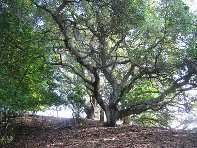
Veilleux waxed rhapsodic about the bay trees all around us: the manifold shapes of trunk, the lush color of the leaves when they catch the sun, and above all the scent, that wonderful smell. "I think Umbellularia californica is the most versatile and under-used California native plant in the landscaping trade," he said.

"Not in my yard," I replied. The mature bay reaches heights of 120 feet, and as wide. He allowed that regular pruning for size might be necessary. Mixed among the bays all around us, oaks and madrones whispered in the wind as if in awe of the bay's position as climax forest community, the ultimate dispatcher of other trees in the ecosystem.

Few explorers would expect to find a beach hidden in the middle of a redwood grove. Yet such incongruities lurk in the mountains above Santa Cruz, where ancient seabeds upthrust millions of years ago by tectonic turmoil gave rise to stark hills of sand now tucked among lush evergreen forests more than five miles from the sea. Fossilized sand dollars and shark teeth in the ground testify to the marine origin of these Santa Cruz sandhills, whose so-called Zayante soils support a rare and unusual community of native plants found no place else on earth.

The Bonny Doon Ecological Preserve is the largest and most accessible of these unique habitats, with 550 acres and a network of trails open to the public during daylight hours. Walking these paths of heavy sand, one expects to hear the roar of the surf around every corner -- yet the ear meets nothing but the sound of a mountain breeze whispering through the surrounding woods.

Here we find a dominant population of the rare and endangered Bonny Doon manzanita (Arctostaphylos silvicola), an upright shrub from 5-15 feet tall with gorgeous silver foliage and a gnarled trunk of deep red vein-like branches. Sunlight shining at an angle through the leaves can cause this foliage to glow as if from within, rendering the landscape otherworldly and magical.

Distant rumblings from city hall portend a boom on Treasure Island, the former Navy base on the brink of becoming San Francisco's newest residential neighborhood. This exercise of urban planning in the middle of the bay will be a closely watched experiment. Early drafts of the master plan have called for sustainable design and green building development, for example, including an open space and landscaping component that emphasizes the use of locally native plants.

No plant is native to Treasure Island -- this 400-acre landmass was built of quarried rock and bay-dredged landfill in the late 1930s. But the first seawalls for that project were raised from the northern shoals of Yerba Buena Island, the natural island now joined with man-made Treasure Island like a siamese twin. And the steep slopes of Yerba Buena Island, though radically altered by invasive weeds and the hand of man, still harbor remnants of the original native flora, a population from which the landscape planners may wish to draw their inspiration.

Consider the coast red elderberry (Sambucus racemosa var. racemosa), enthusiastic seeder of moist forest margins, a proven survivor even in the deepening shadows of eucalyptus and monterey pine. This robust deciduous shrub can reach tree-like heights of 15-20 feet, filling the middle space beneath a taller canopy with a cheerful bloom of frothy white blossoms from March through July. Just now the fruit has begun to form, dramatic clusters of scarlet berries adored by birds. After the leaves drop in late fall, the bare elderberry still holds interest for its branches, which have a large pith and are easily hollowed out. The Ohlone used these twigs for flutes, whistles, and clapper sticks (a drum alternative); indeed, the genus name Sambucus pays homage to the Greek sambuke, a musical instrument made from elder wood. Excellent as a specimen plant in the garden or as a focal point in an urban park, and a tasteful alternative to cotoneaster, the coast red elderberry should rank high on anybody's landscaping wish list.

Water paints with shifting colors the divided contours of the Valley of the Moon in Sonoma, California. The blues and greens of oak and bay forests on protected north-facing slopes complement the fire and earth tones of chaparral on the south-facing sides. Here at the southern end of the basin, riotous riparian woodlands follow snaking Stuart Creek through a steep canyon to Agua Caliente, the pepper of volcanic springs beneath the valley floor. Lowland meadows collect water in seasonal puddles, where vivid wildflowers come and go with the equinox.

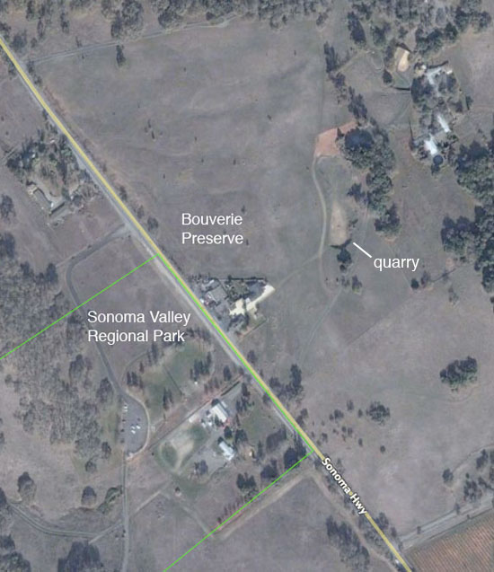
On two sides of the Old Sonoma Highway, one such meadow is divided by two authorities. The southwest side of the field falls within the boundaries of Sonoma Valley Regional Park, a public 162-acre parcel near Glen Ellen; the northeast side belongs to the Bouverie Preserve, a 500-acre jewel in the private necklace of Audubon Canyon Ranch.

A former quarry beside the Bouverie visitor center (rumored to have supplied the stone for the nearby Jack London House) is today a vernal pool, a depression of hardpan that fills with water in winter and goes bone dry in summer. Smaller pools and swales sweep the adjacent meadow in a network of linked seasonal wetlands -- up to Highway 12, of course -- then continue as another isolated system on the other side of the road. Spring sees the transition from flood to drought in these unforgiving flats, a mere sliver of time in which a succession of highly adapted native plants take the stage and dance with the reaper for a week or two, then disappear again.

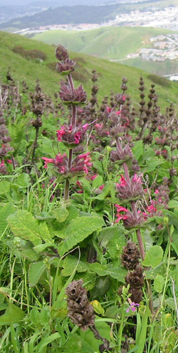
Passover comes this Sunday, a rite from the Biblical story of Exodus, wherein the enslaved Israelites win their freedom from Pharaoh. It seems a fitting context for a discussion of The Acres, an indentured ecosystem on the wildland-urban interface.

These substantial and privately-held native grasslands rise between the town of Brisbane and the state and county park of San Bruno Mountain. A walk here is like a page from the California history book -- steep hoary stands of melic and fescue athwart canyons of buckeye and oak, and vast savannahs of butterfly sage punctuated by johnny jump-up, silver lupine, and broadleaf stonecrop, the larval food plants of rare and endangered butterflies.

Carved into jigsaw-puzzle pieces by an "unrecorded subdivision" (i.e. illegally) in the 1930s, with titles now held by hundreds of individuals, The Acres live in a state of bondage. Houses already cover twenty of the original 111 parcels (all on the lower slopes), and developers have mapped routes for possible roads and building envelopes throughout the remaining 120 wild acres. Opinions among owners radically diverge: some would like to preserve their land as open space, while others want to build. One fellow proposed turning his one-acre parcel into an Indian casino. Where is Moses when you need him?

The near-horizontal pitch of these slide-prone grades would appear to discourage your average builder -- but the Bay Area real estate market is anything but average. Already the narrow private roads on the lower, comparatively gentle slopes "typically do not meet fire code standards," according to the City of Brisbane. Some of the proposed new streets in the steeps are merely drawn on paper; others follow the mad path of Virgil Karns, an eccentric local landowner from decades ago who joyrode his bulldozer up and down these sheer ridges in his spare time.

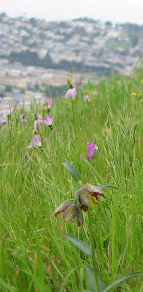
Often charming, occasionally gritty, surely up-and-coming -- witness the real estate renaissance of Bernal Heights, S.F.'s neo-boho neighborhood where once-dilapidated homes now zoom at the speed of commerce beyond the million dollar threshold. Yet a liferaft floating at the center of this frothing urban sea remains undeveloped: Bernal Hill Park, a peak with a far older balance sheet of life, death, and rebirth.

Start your walk on the south side, where all good rags-to-riches stories begin. There on the wrong side of Bernal Heights Blvd. (south of the road), a proud blooming patch of hummingbird sage (Salvia spathacea) bears up in a weed-choked vacant lot. This plant grows in oak woodlands, chaparral, and scrub along the coast of central and southern California, reaching its upper limit in the Bay Area, where it thrives; it spreads by rhizomes and makes an outstanding groundcover in both sun and shade. The lance-shaped leaves give the finest fragrance of any sage you'll find, and the dramatic pink blooms draw squadrons of hungry hummingbirds. The rogue patch in the vacant lot is the last (known) survivor of the naturally occurring species on Bernal Hill -- so if you find it, please treat it with care.

Continue north and uphill, where 20 acres of grassland house other jewels from the pre-Colombian flora. Shooting stars (Dodecatheon spp.), for example, have burst aloft early and prolifically this year; these members of the primrose family develop shuttlecock flowers pointed like rocket ships, peppering the meadow with gorgeous violet flames. The botanical name is Greek for "twelve gods," and with as many easily intergradable species in the genus, the promiscuous taxonomy of Dodecatheon feels worthy of those old landlords of Olympus. Bernal Hill is the type locality for Dodecatheon clevelandii ssp. patulum, a noteworthy subspecies that thrives on serpentine. Go see it now in plenty on the north and northwest slopes beneath the microwave tower, facing the skyline of downtown.

Living Large in Muir Woods

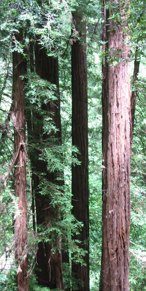
The trappings of prosperity pursued by contemporary city dwellers emphasize the appeal of "living large," hinting that the ends of financial aggrandizement will justify any means. But here in the Bay Area, we also enjoy a wealth of nearby natural resources that remind us of just how small any one person is in the grander scheme of Earth. These two sides of the spectrum meet in the old-growth redwood forest of Muir Woods, located only 15 miles north of San Francisco's financial district yet rooted in a time that predates our mercantile madness by millions of years.

Here the coast redwood (Sequoia sempervirens), the tallest species of tree in the world, grows to heights of 250 feet and dwarfs the oak, bay, madrone, and douglas fir that usually dominate the canopy of northern California forests. Walking among these giants, one feels the hushed weight of history, a sense of being watched over by the elders. In fact, many of the specimens here were already reaching for the clouds when Columbus set sail -- the mature trees of Cathedral and Bohemian groves average between 600 and 800 years old, with the oldest at least 1,100 years old. But even these are young for a redwood, which can live to more than 2,200 years of age and grow over 350 feet tall.

First-time visitors to Muir Woods often crane their necks and stare upward like tourists in downtown Manhattan, spellbound at the spectacle of the skyscraping trees. But don't forget to look down -- the understory deserves its share of attention too, especially now at the beginning of the year when some of our greatest botanical treasures come into bloom.

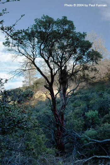
"I just hiked to the top of Cedar Mountain Ridge," wrote Pete Veilleux, proprietor of East Bay Wilds landscaping, "and found some very cool plants including a bigberry manzanita 40 feet tall!"

Incredulity rippled through the native plant coven. The standing record for any manzanita was 32 feet, according to Tilden Park Botanical Gardens local expert Bert Johnson. A 40-foot manzanita has never been recorded. Veilleux explained that he hadn't measured exactly, but only eyeballed the height; Johnson urged him to return as soon as possible with a yardstick or a tape measure. Tempted by the thrill of the chase, I joined Veilleux and Paul Furman, landscape architect and photographer, to revisit the mountain and measure the monster manzanita.

Cedar Mountain Ridge rises near Livermore in southeastern Alameda County between the Crane and Rocky Ridges, a veritable wonderland of rare and unusual plant communities. It's 20 miles up Arroyo Mocho to this enchanted region, mostly private property off-limits to the public. Veilleux discovered the manzanita in a remote canyon above the Los Mochos boy scout camp. "I would never trespass," he said, then elaborated with a grin: "I try not to get caught."

I phoned the boy scout camp three times requesting permission for an informal botanizing expedition. My calls were not returned.

The well-groomed greenery of San Francisco's Golden Gate Park demonstrates the power of mankind to transform an uncultivated landscape into a recreational playground. Once a windswept wildland, these former sand dunes and occasional oak groves were staked out in the late 19th century by massive plantings of eucalyptus and monterey pine, thereby stabilizing the sandbank and forming the foundation into which horticulture could sink its roots. Great lawns and buffalo paddocks, rose gardens and tulip beds, an arboretum and a Japanese tea garden and a conservatory of flowers and more arose to meet the desires of a growing city and its park-loving public.

But hidden among these thousand-plus acres of manicured verdure, small pockets of the original native flora yet live. Consider the sanctuary of Strawberry Hill, a natural knoll in the center of man-made Stow Lake, where an old oak woodland draws upon ancient strands of history even as the modern age encircles it with tourist-driven paddleboats.

The hill takes its name from the wood strawberry, Fragaria vesca, which once grew here in vigorous plenty. Alas, it has been largely displaced by cape ivy and iceplant, those vigorous weedy interlopers from South Africa -- yet careful scrutiny of these sandy slopes will reveal patches of Fragaria still clinging to survival. The botanical name derives from the Latin for "fragrant," and indeed the smell of wild strawberry foliage is delightful, especially right after a rainshower. Similar in habit to its agricultural cousin, but with smaller fruit and a high tolerance for summer drought, the wood strawberry thrives in the partial shade of forests throughout the Bay Area, a natural choice for San Francisco gardeners seeking a good groundcover for underneath oaks or in otherwise sun-challenged yards.

Connections Run Deep in Lagunitas Creek

November rain sings a song of connectivity. It completes the natural cycle, raising the rivers and recharging the aquifers, pouring from the air to the earth and back to the ocean whence it came. We find an extraordinary example of its ramifications in western Marin County, where the rainfall not only paints a fresh coat of green on the sun-blasted hills but also summons a legion of deep sea creatures to return to the highland haunts of their birth.

The Lagunitas Creek watershed begins on the northern slopes of Mount Tamalpais and flows on the landward side of the Bolinas Ridge approximately 25 miles north to drain into Tomales Bay, fed by numerous streams along the way including Nicasio Creek, San Geronimo Creek, Olema Creek, Devil's Gulch and Deadman's Gulch. At more than 100 square miles, it is the largest watershed in Marin County, but its stature stands all the higher for the abundance of life it supports.

The riparian plant community here exists in layers of height-based competition for sunlight. Redwoods, Douglas firs, California bays, and madrones reach for the sky, while beneath them willows, alders, big-leaf maples and dogwoods jockey for position in the increasingly dappled shade. Hazelnuts, huckleberries, and elk clover fill in the lower levels, adapted as they are to the darker conditions near the forest floor.

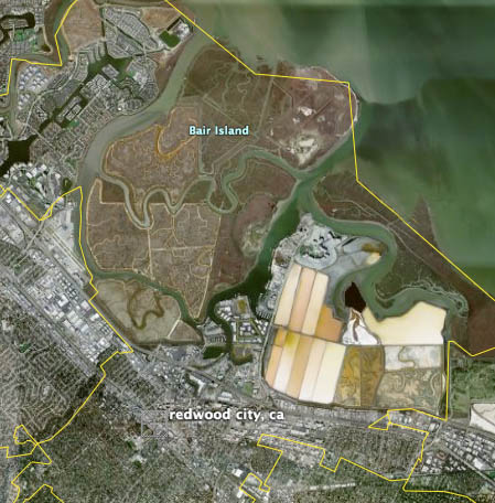
At the confluence of Redwood Creek and San Francisco Bay in southern San Mateo county, three islands shape-shift in drifting piles of river silt and sea salt. Boundaries may blur, but Smith and Corkscrew Sloughs divide this trio clearly into Inner, Middle, and Outer Bair Island -- the first a popular Redwood City jogging and dog-walking spot connected to the mainland at Whipple Ave., the latter two accessible by kayak. These sandbanks and mudflats have undulated over eons in a long, slow waltz between sedimentation from the river and erosion from the tides, creation and destruction inseparable.
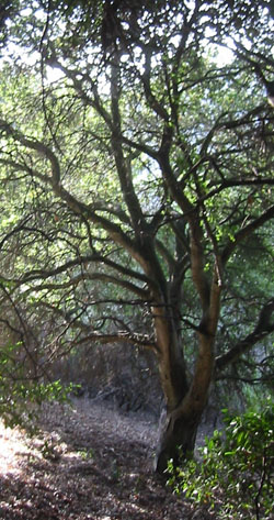
Here at the corner of ocean and land, the air hangs with the sharp aroma of salt and the healthy reek of decay and erumpent life. High tide deepens the channels between the raised flats; low tide reveals tangles of pickleweed connecting them. On higher ground, yellow blossoms of gumplant wave in the breeze, and pink rosemary blooms of alkali heath hug the ground -- a contrast to the stark rectangles of vivid red, orange, and white at the adjacent industrial salt ponds.

Tidal marshes in the San Francisco Bay provide critical habitat for a vast array of species including young salmon and steelhead adjusting to life in saltwater, harbor seals hauling out on the marshes to breed and whelp, shorebirds like snowy plovers, shovelers, avocets and black-neck stilts prowling the mudflats for mollusks, and endemic endangered birds and mammals like the California clapper rail and the salt marsh harvest mouse who live only in the tidelands of the Bay.

The salty smell of the marsh evokes ancient origins. Just as the first creatures arose from the primordial sea, modern-day mothers bring forth babies drenched in pregnancy's brine. The theme has expressed itself in human mythology from at least the time of Babylon, when Marduk (the god of storm) established lordship over the other deities by killing the chaotic Tiamat (saltwater) and creating the world out of Tiamat's body. This cleft between dry land and deep sea is the mother of us all.

Step Back in Time to Leona Canyon

On a mountain range in Oakland, a lioness prowls her historic canyon. Rugged ridges and riotous riparian zones cleave the oak woodlands and chaparral into complementary halves. This is the intersection of sunlight and shadow, of wilderness and the urban, of knowledge and the unknown.

Leona Canyon Regional Open Space Preserve lies between Merritt College and the housing developments on Keller Avenue, a tether to natural history hemmed in by roads on all sides. Spared from the bulldozers by a land deal between builders and the East Bay Regional Park District in 1979, these 271 acres harbor diverse communities of native plants and sustain heritage populations of bees, butterflies, birds, and beasts of the field.

True, today the large mammals here are mostly joggers and off-leash dogs. But a hike on the 1.3-mile Leona Trail still feels like deliverance from the streets, a time warp back to the original trees that gave their lives and their name to the city. Amid the development of surrounding Alameda County, from which vehicle traffic now encircles the canyon, this slice of the lost wilderness yet lives.

Some sunny September morning, leave your car in the parking lot on Canyon Oaks Drive and walk west into Leona Canyon. Below and to your left, the flood plain of the creek has run nearly dry -- no rain in the past several months, after all. But the robust willow and hazelnut trees prove that water still flows here, even if only underground in the dry season. Climb farther into the canyon, where the water becomes more abundant, and soon you'll hear its voice babbling from the undergrowth.

As the trail ascends, the rising sun at your back sends a long shadow before you on the path. You now see compass points appearing on the landscape: two different plant communities on either side of the stream.

A Call for Mercy at Lake Merced

Water and sand straddle the symbolic spectrum of living: while the former is biologically essential, the latter evokes the lifeless dunes of the desert. Yet here in San Francisco, where dunes define our geology and "normal" is anything but, the sandy banks of our largest lake sustain a population of drought-tolerant dune plants that belie the dominant paradigm. Such a flourishing of life under inauspicious circumstances distinguishes our local flora.

Our subject is Lake Merced, where today the trappings of modern recreation capture the bulk of public attention. Duffers flock to the Harding Park and Jack Fleming golf courses on the eastern flank, where grassy fairways and manicured greens attest to the power of irrigation; fishermen angle from designated piers for stocked trout in depths that have mercifully risen from their recent historic lows; and bikers and joggers ply the paved roadways that girdle the shifting shores. As in so many other natural areas within the urban setting, exotic invasive plants have followed close behind human activity: stubborn iceplant (Carpobrotus edulis) blankets many exposed banks, while meddlesome cape ivy (Delairea odorata) scrambles from dense thickets up into the bark-shedding heights of ubiquitous Eucalyptus and fast-growing stands of Monterey pine.

Nevertheless, elements of the original flora still survive here, thanks in large part to volunteer groups like the Friends of Lake Merced and city organizations like the Natural Areas Program. The best spot to admire their work is at the Mesa, a peninsula on the northern shore of the east lake (across Lake Merced Blvd. from the Lakeshore Elementary School), where a restoration task force has removed the monocultural iceplant and helped to swing the natural balance back toward the diversity of native plants that truly belong here.

A sandy footpath skirts piles of uprooted, decomposing iceplant, and leads into a rich dune-scrub plant community that upholds the legacy of our past. The prostrate form of coyote brush (Baccharis pilularis), a dense evergreen shrub reaching 1-2 feet in height, anchors the landscape. This particular population blooms earlier than its statewide brethren, which tends to flower in late fall, so August finds the coyote brush of Lake Merced covered in the curious whitish-yellow fuzz that serves to underscore its common name. These furry-looking blossoms may not rank among the world's most attractive, but they sustain more than 600 species of beneficial insects and the birds that feed on them, thus rendering coyote brush among the most important wildlife plants we know.

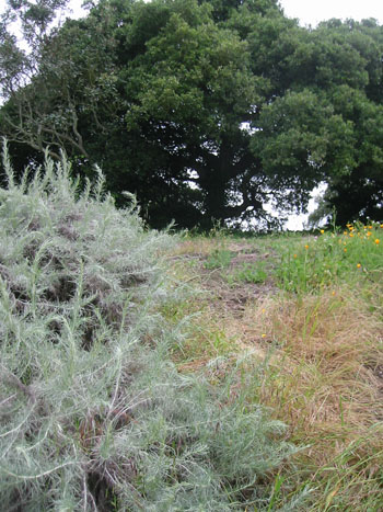
Words bestow immortality: just as the book outlives its author, a name can outlast its human corollary. Many California landmarks bear the names of historic families, for example, providing a subtext that enhances our sense of local identity. The story behind each name can add even greater value, much like the bones of our ancestors that enrich the earth in deepening layers of fertility.

Take Mount Wanda, a golden-brown foothill of grassland and old-growth oak perched between the East Bay's rural Alhambra Valley and the highly industrial town of Martinez. This 660-foot peak was named for John Muir's eldest daughter, an apt parallel if we recognize such preserved natural areas as the great man's "other progeny," and his more enduring legacy. Muir married into an established local ranching family and lived here in Martinez from 1882 until his death in 1914. His modest writing desk, still there on an upper floor of the old family mansion, witnessed the work that saved Yosemite, launched the Sierra Club, and laid the foundation for the National Park Service. When necessity prevented Muir from traveling to the high Sierra, he contented himself with long walks through these low foothills, where the time-gnarled limbs of the oaks served as a lifeline to the desolate nature he craved. Today the 325 acres of Mt. Wanda, together with the Muir house and the adjacent Martinez Adobe, are open to the public as a national historic site.

These old oaks, untouched by industry, stand in stark contrast to the chemical plants and oil refineries of modern Martinez. The valley oak (Quercus lobata) lives to be 300 years old with an immense crown often topping 100 feet in both height and span; its silhouette of gracefully drooping limbs assumes the shape of a gigantic grape vine, and its deciduous leaves are deeply lobed, hence the specific epithet. The blue oak (Q. douglasii) earns its common name from the bluish-green tint of its foliage, also deciduous, and it can reach 20-60 feet tall growing in thin soils or from crevices between rocks. The coast live oak (Q. agrifolia), with its burly trunk, and the interior live oak (Q. wislizenii), usually of more modest stature, add their serrated evergreen leaves to the canopy. The word "Quercus" comes from Latin; it is an ancient name for oak that predates ancient Rome.

Taking the Waters at El Polin

Predicting the future or understanding the past -- which is more important? Ask the Muwekma Ohlone, who settled the village of Petlenuc beside El Polin some 5,000 years ago; they knew lots about the local plants and animals, but had no idea this land would become the Presidio of San Francisco, one of the most valuable pieces of real estate in the world. Their simple life ended with the 1776 arrival of Captain Anza, who chained them up and founded this fort as the northernmost reach of the Spanish crown. The following two centuries of military occupation under the flags of Spain, Mexico, and the U.S. shocked and awed this landscape into spectacular transformation, but neither quadrangles nor barracks nor landfills nor quarries nor the gloom of an historic Australian forest have stayed the original native plant communities from their appointed lifecycles: many of the "original inhabitants" still grow on the Presidio's distinctive bluffs, beaches, and dunes, telling a tale older than mankind.

Among our oldest local legends concerns the Oja de Agua of El Polin, a freshwater spring in the Tennessee Hollow watershed (the Presidio's southeast corner). The bulk of the military's water supply always came from Mountain Lake to the west, but the seasonal pulse of El Polin commanded greater mystery and attraction. Myth held that any maiden who drank of its waters (particularly during a full moon) would be assured great fertility with an abundance of twins, while any man so indulging would enjoy a vigorous jolt of pre-Columbian Viagra. In his Discorso Historica of 1876, General Vallejo described the "very good water" which "demonstrated miraculous qualities"; he cited the numerous offspring of garrison wives, "all of whom several times had twins," and listed them by family name and number of children produced (13, 18, 22), a laudable multiplication he attributed to "the virtue of the water of El Polin, which still exists."

The name El Polin derives from the old Spanish word for a giant wooden roller used dockside to load cannon and treasure aboard galleons; due to the phallic appearance of these logs, the word enjoyed widespread use as vulgar slang for the penis. Sources hint at Ohlone origins for the legend of the water's fucundity, but the nickname is 100% macho Spaniard.

Daily we drive our cars or ride the bus to the city, glad for modern transportation yet melancholy for the fate of paved-over Nature, a presumed paradise lost. But pockets of the original wilderness still flourish among our Bay Area motorways, just as a rare flower might sprout unnoticed in the middle of a sun-baked field. These natural sanctuaries are portals that can transport us to an earlier time. In Marin County, for example, where the Tiburon peninsula meets the mainland, surrounded by Corte Madera's housing developments and adjacent to Hwy. 101, the open space preserve at Ring Mountain sustains a living connection with history, a lifeline to yesterday's forgotten truths.

Most of present-day Ring Mountain once lay under the sea during the age of dinosaurs. Then oceanic volcanoes and tectonic movements caused massive disruptions, and the floor of the Pacific Ocean crashed into the North American plate. For a hundred million years, at the speed of one foot per decade, the collision sheared off white pillow lava and red radiolarian chert from the seabed and thrust it into the leading edge of the continent. Submarine landslides contributed tiers of primordial sand and mud (greywacke and shale), while high-pressure blueschist metamorphics like serpentinite and lawsonite bubbled up from deep inside the earth. These soapy-textured stones -- mixed with thick layers of lava and petrified microscopic sea creatures fractured and buckled over eons -- have brought a legion of contemporary geologists here to read the story of deep time written in Ring Mountain's exposed rocky strata.

Growing on those serpentine odes, a native grassland tells more recent tales measured in mere thousands of years. Drought-tolerant perennial bunchgrasses push their roots twenty feet deep into the hillside, both physical and metaphoric anchors once revered by those who lived here and now all but forgotten. Their light green shoots in spring turn deeper colors in summer, and their long graceful culms nod in the breeze with a shimmering inflorescence. By nature of their adaptation to this toxic serpentine soil, these long-lived grasses were spared the invasion of exotic annuals that so transformed the majority of our state's remaining natural areas. Here we see California as it was before the superhighway and the shopping center, before the industrial farm and the rancho, prior to the arrival of the white man.

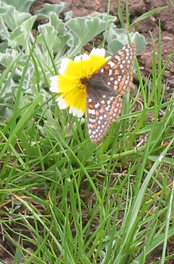
Shifting identities and strange alliances occur along the wildland-urban interface, where natural ecosystems collide with cities and the side effects of human industry. Plants and animals living along these intersections must adapt to changing conditions, or perish. We now raise the curtain on a drama where cows protect rare and endangered butterflies from certain death by automobile, with a dramatis personae of native wildflowers and exotic grasses playing supporting roles.

Coyote Ridge, a large serpentine grassland two miles wide and fifteen miles long, lies just south of San Jose along Hwy 101. Serpentinite is the California state rock; this bluish-green stone was formed in darkness near the center of the earth, heated to a high boil and bubbled up through surface fractures (in this case the San Andreas Fault) to the open light. Most plants cannot grow on serpentine soil -- not enough nitrogen, too much magnesium -- but a select group of natives evolved in tandem with this infertile habitat, and they can survive it. Such an inhospitable medium also holds off the weedy European annual grasses that have so transformed the rest of our state. The beauty of the serpentine grassland therefore derives not just from its dazzling burlesque of April wildflowers, but because it shows what California looked like 300 years ago, when native grasslands embraced a third of the state; today they cover less than 1%.

Where did all the California grasslands go? First they were over-grazed by cattle, starting with the Spanish in the late 18th century and then again during the Gold Rush, when a million head of beef were shipped west to feed hungry miners. Many surviving grasslands were soon plowed under for agriculture and paved over for development. Those few remaining then suffered from poor fire management policy, where "wildfire suppression" was the only rule -- as opposed to the practice of Native Americans, who understood fire's regenerative power and set "controlled burns" in the grasslands for thousands of years. The final blow was the arrival of European annual grasses better adapted to the above conditions, growing taller and more quickly than the native bunchgrasses, self-seeding so prodigiously as to choke out any competition.

Right now the 7000 acres of Coyote Ridge are awash in shimmering colors: rolling yellow carpets of tidy tips and goldfields, bright swaths of purple owl's clover and red jeweled onion, a vision of nodding white fairy lanterns and blue spikes of western larkspur, an exaltation of cream- and buttercups. Hairy black and yellow Bay checkerspot caterpillars gorge themselves on the low silvery foliage of dwarf plantain, and adult Bay checkerspot butterflies tipple nectar from tidy tips and wild onions. The proverbial birds and bees visit other wildflowers in promiscuous plenty, performing their sexual duties. The web of biodiversity here includes more than 100 plant species, with an average of 20 species occurring per half-meter-squared (approximately the area you can fit your arms around); this richness of flora in turn supports countless populations of tiny creatures that creep, scurry, burrow, and fly.

Nursing Biodiversity on Twin Peaks

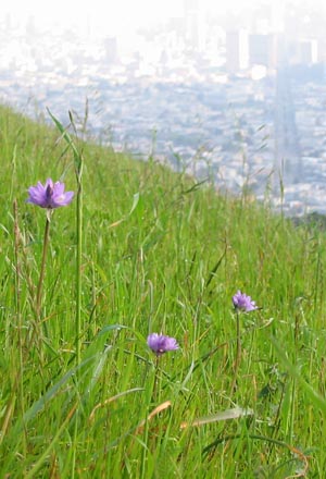
Once upon a time, Twin Peaks stood as one mountain, a united man and wife. But the couple quarreled long and bitterly, until at last the Great Spirit cleaved them with a bolt of lightning. The neighborhood has been quiet ever since -- or so say the chroniclers of Indian legend.

Those Indians, alas no longer here to confirm or deny the tale, likely marked a drastic change in the neighborhood with the arrival of the Spaniards, who fortified the nearby Presidio in 1776 . Maps from this period call Twin Peaks "Los Pechos de la Choca" or "The Breasts of the Indian Maiden," of whom General Vallejo's botanically minded son once remarked, "Never have I seen a cultured woman half so fair as this untaught, unadorned daughter of the wilds."

Young Vallejo may in fact have personified the Franciscan flora, the smallest floristic region in California. This curvaceous landscape of flinty chert and sand dunes supports a body of low-growing coastal scrub and grassland reclining between the regions of Mendocino/Sonoma to the north and the Santa Cruz mountains to the south, both of which favor a taller Douglas fir-redwood association all the way down to the sea. Rich with texture, aroma, and color, our fair maiden helps us define our local identity. Her toes curl around Sign Hill, blazoned with "South San Francisco: The Industrial City" in block letters visible from the freeway and the airport. Her long legs are San Bruno Mountain, stretching for several miles of the inner peninsula with Brisbane and Colma snuggled on either side. Above the rude garter of Daly City her saucy flank swells at Mt. Davidson, then slims to a waistline and rises again to the torso topped with Twin Peaks, shoulders at Diamond Heights and Corona Heights, arms embracing Sunset Heights and Bernal Hill, with long tresses of serpentine flowing out to Bayview and into the Presidio.

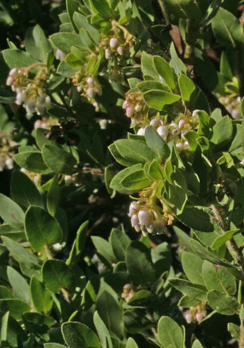
Here in earthquake country, the land moves in puzzling ways. Take Montara Mountain, a San Mateo landmark at the uppermost edge of the Santa Cruz Range, whose steep heights plunge dramatically through the fog down into the sea at Devil's Slide. It looks like the western edge of North America, but in fact this granite and sandstone formation sits on the eastern edge of the Pacific plate, a tectonic "island" riding north along the shear of the San Andreas Fault. This mountain originated with the sierra of Southern California, and has been grinding its long, bumpy way up the coast toward San Francisco for millions of years, at speeds approaching one meter per century.

Now protected as San Pedro Valley Park in Pacifica, the slopes of Montara Mountain support a relict plant community more like those of Santa Barbara and the Channel Islands than its neighboring natural areas on the Peninsula. A strenuous switchback trail climbs to the North Peak through dense coastal chaparral of Montara manzanita (Arctostaphylos montaraensis) and minor giant chinquapin (Chrysolepsis chrysophylla var. minor), two noteworthy specimens. The former is a local endemic found nowhere else on earth, growing 3-15 feet tall with tightly clasping silver-green leaves held upright, stems covered in white bristles, and the red gnarled trunk for which manzanitas are prized; the latter is uncommon in this region, a large shrub or a small tree with boat-shaped leaves dusted with gold on their undersides.

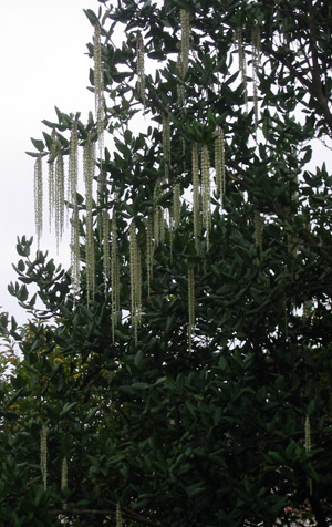
Leave your car in the parking lot on Skyline Blvd. in the Oakland Hills and step through the unknown, remembered gate onto the huckleberry path. Inhale the aroma of rain on the wind, a perfume mixed with the bouquet of a mature bay forest. Sheer rocky knolls punctuate the canyon, its story a potboiler of earthquakes and eruptions. Mist drapes maverick oaks and madrones in fleeting gossamer gowns, and paints the tops of trees on the ridge across the valley. The voice of the river rises from below, a music older than memory.

You have just entered the Huckleberry Botanic Regional Preserve, a living time capsule. For the next few hours, try to fit your calendar and your clock into the big picture. Forget about your spouse's birthday next week, your kid's piano recital next month, and that quest for a promotion next year. Quit wondering what to nickname the current decade, and get over the gravitas of the 21st century. Millennia are still too small -- stop looking at the whale through a microscope. Take a moment and adjust your units.

The geology here is shale and radiolarian chert, the petrified shells of microscopic sea creatures who lived half a trillion years ago. By comparison, this formation's existence as a mountain ridge is still a puppy, upthrust from the ocean floor a mere 12 million years ago. Much of the present native plant community has grown here for 5 million years in a relict association found nowhere else in the East Bay, but only in areas along the California coast like the Channel Islands, Point Conception, and Montara Mountain.

At the trailhead for the huckleberry path, a wooden bin holds informational fliers and a printed key for a self-guided tour, where17 numbered stations along the trail identify plants and communities described in the key. To watch history evolve in the proper direction, follow the self-guided tour backwards: take a right where the sign for the Huckleberry Path points left, and walk the trail counter-clockwise.

The character of this flora is marked by succession, that natural sequence of changes by which certain groups of plants are replaced by others. The laws are dictated by the chert, a harsh and nutrient-poor soil that limits the varieties of plants that can live here; yet succor arrives with moisture blowing in from the Golden Gate, sustaining any species that take hold. Hot summers and frequent wildfires write an agenda driven by flame.